Dholera, India’s first greenfield smart city, is a flagship initiative under the Delhi-Mumbai Industrial Corridor (DMIC) project. Strategically located in Gujarat, Dholera is rapidly emerging as a futuristic urban centre, designed to be an engine of economic growth and sustainable development. With the Final Development Plan of Dholera now approved, the region is witnessing significant interest from investors, developers, and homebuyers. This blog delves into the Town Planning Map of Dholera, offering detailed insights into Dholera TP Schemes, zoning, and how the city is transforming through meticulous planning.
Understanding the Final Development Plan of Dholera
The Final Development Plan (FDP) of Dholera is a comprehensive blueprint formulated to guide infrastructure development, urban zoning, and real estate growth. Spearheaded by the Dholera Special Investment Region Development Authority (DSIRDA), this plan covers a vast area of approximately 920 square kilometers.
The plan is designed to accommodate residential, commercial, industrial, and recreational spaces, making Dholera a self-sustainable urban ecosystem. The Urban Development Map of Dholera reveals a grid-based city layout that ensures high-quality infrastructure, seamless transportation, and efficient land usage.
Town Planning Map of Dholera: A Structured Urban Layout
The Town Planning Map of Dholera is at the core of its development strategy. The city is divided into several Town Planning (TP) Schemes, each covering a specific zone with unique land use purposes. These maps are not just geographical layouts but strategic documents outlining development control regulations, infrastructure placement, land reservations, and road networks.
Key elements of the Dholera Town Planning Map include:
- Zoning in Dholera for residential, commercial, and industrial purposes
- Strategic placement of green zones and public spaces
- Proposed infrastructure including roads, stormwater drains, and utilities
- Reservation of land for educational institutions, healthcare, and transport
This structured approach ensures that Dholera’s development is not haphazard but aligned with long-term urban goals.
Dholera TP Schemes: Planning Schemes in Action
To ensure uniform development, Dholera has been divided into multiple TP (Town Planning) Schemes. These schemes are micro-level plans within the broader development framework, managed by the Gujarat Town Planning and Urban Development Act.
Notable Dholera TP Schemes:
- TP Scheme 1 and 2: These cover the area closest to the activation zone and are among the first to be developed. They include land earmarked for residential societies, commercial hubs, and public services.
- TP Scheme 3 and beyond: Encompass expansion zones and focus on industrial growth and logistic support.
Each TP Scheme defines the Floor Space Index (FSI), setback requirements, and open space mandates. For those looking to Buy Plots in Dholera, understanding these schemes is critical to choosing the right investment.
Zoning in Dholera: Integrated and Forward-Thinking
The concept of Zoning in Dholera is revolutionary. Unlike unplanned urban growth seen in many Indian cities, Dholera uses zoning as a foundational tool for sustainable development. The city is divided into zones such as:
- Residential Zone – Comprising various housing types and townships
- Commercial Zone – Hosting retail markets, malls, and office spaces
- Industrial Zone – Catering to manufacturing, warehousing, and logistics
- Recreational Zone – With parks, gardens, and eco-friendly spots
- Public & Semi-Public Zone – Allocated for institutions, utilities, and civic amenities
This clear zoning allows for smooth coexistence of various sectors and significantly boosts the efficiency of urban infrastructure.
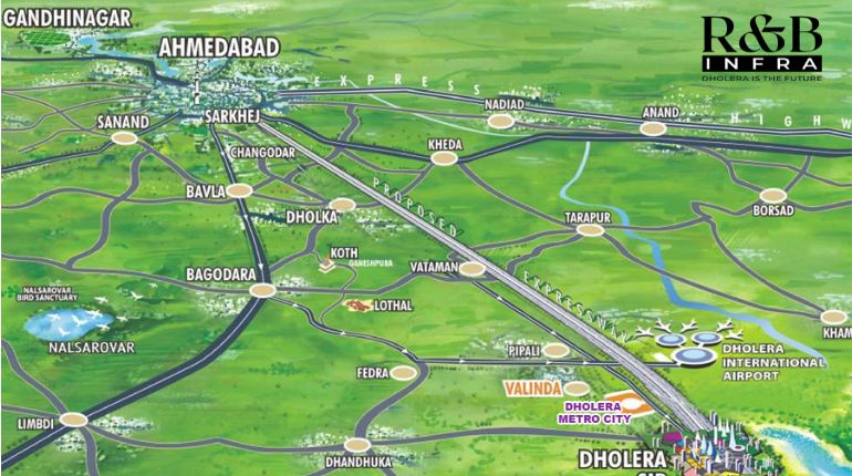
Dholera Smart City Map: Visualizing the Future
The Dholera Smart City Map provides a real-time view of how the city is taking shape. With digital overlays, this map offers insights into completed, ongoing, and proposed projects.
Key features visible on the Smart City Map:
- ABCD Building – Administrative and Command Control Hub
- 6-Lane Expressway – Linking Dholera to Ahmedabad and Bhavnagar
- International Airport – Under development and a game changer for global connectivity
- High-Speed Rail Corridor – Part of the Delhi-Mumbai infrastructure corridor
The map also shows planned zones for smart homes, solar parks, and EV zones, making it an essential resource for anyone involved in Dholera Real Estate.
Dholera Real Estate: A Growing Investment Destination
The rise of Dholera as a smart city has attracted both institutional and individual investors. With government-backed infrastructure, transparent land acquisition policies, and smart zoning, the Dholera Real Estate market is becoming increasingly lucrative.
Highlights of the real estate boom:
- Residential plots available under TP Schemes at competitive prices
- Commercial plots in proximity to industrial and logistics zones
- Industrial lands tailored for SMEs and large enterprises
- Appreciation potential due to upcoming airport, expressway, and metro rail
The clarity offered by the Town Planning Map of Dholera helps investors assess location benefits, surrounding developments, and connectivity – all of which are vital for a sound investment.
Booking Open in Dholera: Time to Take Action
With Booking Open in Dholera for multiple TP Schemes, this is the right time for early movers. Plots are available for residential, commercial, and industrial use. As the infrastructure rapidly progresses, the cost of land is expected to rise, making it a golden window for buyers and investors alike.
Benefits of booking early:
- Prime location selection within TP Schemes
- Transparent pricing under government oversight
- Early access to developing infrastructure and amenities
Whether you are an end-user or investor, the current phase of plot booking gives access to the most promising zones mapped out in the Dholera Smart City Map.
Planning Schemes in Dholera: Ensuring Balanced Growth
One of the strengths of Dholera’s urban vision is the implementation of Planning Schemes in Dholera through democratic processes involving landowners. The land pooling model ensures equitable distribution where landowners contribute and later receive reconstituted plots with added value.
Advantages of the planning scheme model:
- Ensures infrastructure-led development
- Avoids chaotic and uneven urban growth
- Promotes long-term socio-economic planning
- Enhances land value with supporting amenities and roads
Such meticulous planning elevates the quality of life while safeguarding the interests of developers and landowners.
Dholera as a Model of Planned Urbanization
Dholera is a landmark project in India’s urban development story. The Final Development Plan of Dholera, supported by an accurate and detailed Town Planning Map of Dholera, sets new benchmarks in smart city planning. With well-executed Zoning in Dholera, transparent Planning Schemes in Dholera, and real-time updates via the Dholera Smart City Map, the city is poised to become a global investment hotspot.
As infrastructure continues to evolve and Booking Open in Dholera for strategic plots, both homebuyers and investors can take advantage of this well-planned opportunity. With robust Dholera TP Schemes guiding development and a booming Dholera Real Estate market, Dholera represents not just the future of Gujarat—but of smart urbanization in India.
For more information: https://www.dholerainvestments.com/
E-mail ID: contact@dholerainvestments.com
Call Us: +91 8780280999
Location: 412 – Shivalik Satyamev, Sardar Patel Ring Rd, Junction, Ambli – Bopal Road, Ahmedabad, Gujarat 380058
 :
https://www.dholerainvestments.com/
:
https://www.dholerainvestments.com/